Travel Guide
Miyakojima 4-Day Itinerary: Best Beaches, Bridges & Snorkeling in Japan

Want the editable version of this route?
Open the Instaboard template and adapt stops, timing, and notes to fit your trip.
Miyakojima is a subtropical island south of Okinawa where the water is absurdly blue, the beaches are seven kilometers long, and most Japanese people have never even heard of it. Four days is enough to see reefs, cliffs, bridges to tiny neighboring islands, and a town that shuts down by 9 PM, if you pace it right.
Miyakojima sits far enough south that even winter stays mild, but the experience shifts a lot depending on when you go. Summer gives you warm water and typhoon risk, spring and fall are the sweet spot, and winter means empty beaches and crisp light.
Day 1
Day one eases you in: a chieftain's tomb in a residential neighborhood, a windswept peninsula with a lighthouse at the edge of the world, and the island's only real town for dinner.
Tuyumya's Grave
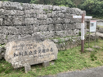
First stop is Tuyumya's Grave, the stone tomb of Nakasone Tuyumya, who ran Miyako in the late 1400s before this island was ever called Okinawa. It's tucked in the middle of a residential part of Hirara: you walk past someone's house and there it is, a centuries-old coral-stone tomb behind a low wall, nationally designated as a cultural property.
The tomb blends local Miyako stonework with Ryukyuan architecture, two cultures meeting in one gravesite. Smooth coral walls shaded by trees, smelling like cut grass and warm stone.
Budget about thirty or forty minutes here. It's small and quiet, a grounding stop before the day opens up into beaches and capes.
Tip: Start at Tuyumya's Grave, a 16th-century Ryukyuan-style stone tomb of the Miyako leader. Walk around the grounds in under an hour. Bring cash for the small donation box and wear comfortable shoes on the stone paths.
Cape Higashi-Hennazaki
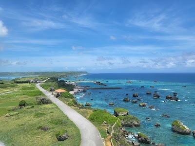
From Hirara, drive southeast to Cape Higashi-Hennazaki, a narrow two-kilometer peninsula where the island just ends and it's nothing but ocean from here to Taiwan. You walk a sliver of land with water on both sides and tall grass bending in unison until you reach a white lighthouse, 24 meters tall and the only vertical thing for miles.
The Japanese government designated this one of the country's 100 best urban parks, which is a bold category for a windswept blade of land at the edge of the nation. The ranking system is either very rigorous or very drunk.
Come in the afternoon because the golden-hour light across the water is the real payoff. There is genuinely no shade anywhere on that walk, so bring water.
Tip: Drive 30 minutes southeast to Cape Higashi-Hennazaki and walk the 2 km peninsula to the lighthouse. Arrive before sunset for the best photos. The cape has no shade, so bring a hat and water on warm days.
Hirara
Head back to Hirara for the evening. This is the largest town on Miyakojima and your only reliable shot at dinner that isn't a convenience store.
The thing to eat here is Miyako soba, and the detail that matters: the toppings go under the noodles, not on top. The island has its own soba tradition distinct from mainland Okinawa.
The streets smell like pork broth and neon hum from the soba shop signs, and you'll hear the local Miyako dialect, which is its own language, mutually unintelligible with Japanese. Eat by seven, not eight. Restaurants close early, and after nine o'clock your options are Family Mart.
Tip: Return to Hirara for dinner and a stroll through the island's dining hub. Many local restaurants close by 21:00, so book your table in advance. Try the Okinawan soba shops near the central intersection.
Day 2
Day two is beach day. You start with seven kilometers of white sand, then climb a dune to find a hidden cove with a stone arch, and wind down at a sheltered marine garden where paddleboards outnumber people.
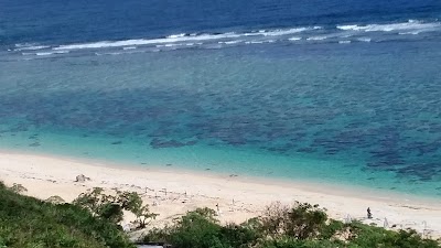
Yonaha Beach
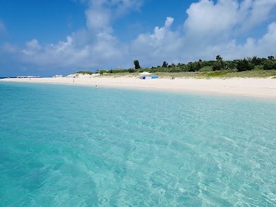
Yonaha-Maehama is the beach that put Miyakojima on the map: seven kilometers of white sand that routinely wins Japan's best beach polls and landed in Tripadvisor's global top 25. The sand squeaks underfoot and the water is so clear your shadow follows you on the sandy bottom.
No food stalls, no exhaust, just the smell of salt. It's stayed this pristine partly because Miyakojima was genuinely hard to reach for decades, so no high-rise hotels ever lined the shore.
Arrive early on weekends because parking fills. Water shoes help at the rocky entry points.
Tip: Spend the morning at Yonaha Beach, 7 km of white sand consistently ranked Japan's best. Arrive early to beat the weekend crowds and secure parking. Water shoes help on the rocky entry points.
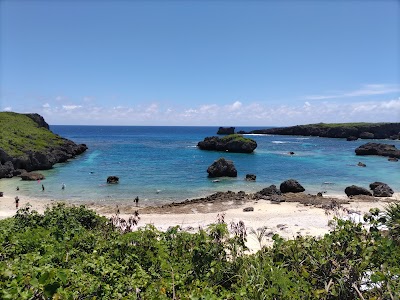
Sunayama beach
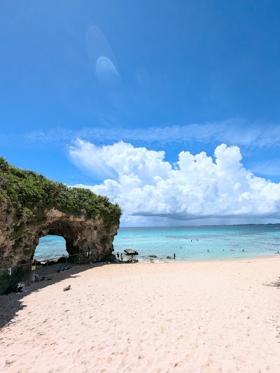
Sunayama literally means sand-mountain beach, and the name is accurate. You walk over a dune and the reveal is a turquoise cove framed by a natural rock arch.
It's Miyakojima's most photographed scene: white sand against cobalt-blue water through a stone window. That dune approach is why. The sudden temperature drop when the ocean breeze hits you is part of the experience.
This is the intimate counterpart to Yonaha's seven-kilometer sprawl, a tiny enclosed cove you can cross in a minute, which also means it feels full fast. Budget an hour or two here, not the whole afternoon, because it's small. Late afternoon light through the arch is the shot to wait for.
Tip: Walk over the sand dune to discover Sunayama Beach's hidden cove and iconic rock arch. The short trail takes 5 minutes. Bring a layer as ocean breezes pick up in late afternoon.
Imgyaa Marine Garden
Finish the beach day at Imgyaa Marine Garden on the south shore, a protected inlet where the water is calm enough that paddleboards outnumber swimmers. The reef-side walking trails here are almost always empty because everyone stays at the water's edge.
Walk the trails and you can see reef fish from above without getting wet. It's a gentler way to close out a big beach day: flat, glassy water, the clunk of paddleboards being carried to shore, and softer late-afternoon light.
If you want to rent a paddleboard, get here by four. The rental shop closes early.
Tip: End at Imgyaa Marine Garden for calm snorkeling coves and reef-side walking trails. Rent paddleboards on-site. Check opening hours as the rental shop closes by 17:00.
Day 3
Day three goes outward. You cross the longest free bridge in Japan to reach Irabu and Shimoji, snorkel a reef that starts steps from shore, then push all the way to a beach most tourists don't know exists.
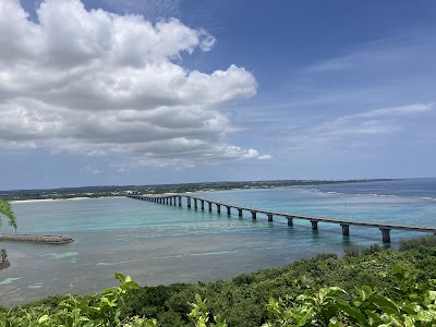
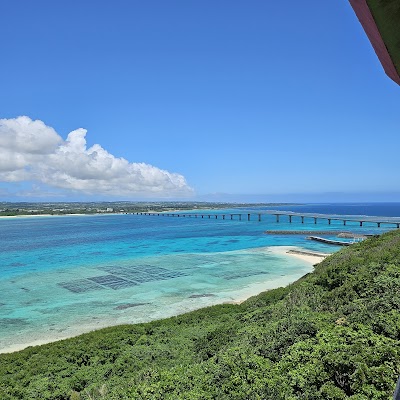
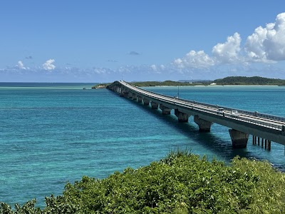
Irabu Bridge (Irabu-Ōbashi)
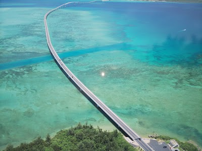
The Irabu Bridge is 3,540 meters of ocean on both sides, the longest toll-free bridge in Japan, and it costs exactly zero yen to cross. Before 2015 you took a ferry here; now it's a five-minute drive across turquoise water, and on calm mornings sea turtles are regularly spotted from the railing.
The color shifts as you cross: shallow turquoise near the shores, deeper blue in the middle, and a faint vertigo from having open water on both sides of a narrow road.
Cross early because tour buses arrive mid-morning and the bridge is narrow enough that trucks make the whole thing feel less leisurely.
Tip: Drive across the 3.5 km Irabu Bridge with turquoise views on both sides. Arrive early to avoid tour-bus crowds and stop at the halfway viewpoint. Sea turtles are often spotted from the railing on calm days.
Yoshino Kaigan Beach
Yoshino Kaigan is where you actually get in the water: the best snorkeling beach on Miyako, with coral reef formations starting steps from the sand. You put on a mask, walk in, and you're surrounded by tropical fish.
The reef is that close, no boat ride, no long swim out. The water here is a deep emerald, not the postcard turquoise of Yonaha. The reward is underwater, not on the surface, so adjust your expectations before you arrive.
Morning is the move because afternoon winds kick up chop that kills visibility. If you want the best coral spots, prebook a guided snorkel tour.
Tip: Snorkel Yoshino Kaigan Beach on Miyako's east coast before heading to Shimoji. The coral reef maze is steps from shore. Prebook a guided snorkel tour to see the best spots safely.
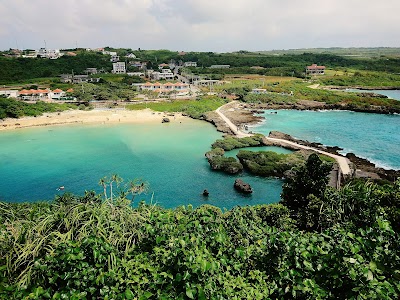
Nakanoshima (Kayaffa)
The last stop is Nakanoshima Beach, also called Kayaffa, on Shimoji Island's southwest coast. You cross two bridges to get here because it's the farthest point of the whole trip.
This is the quietest beach you'll visit: no facilities, no vendors, no music, just waves on coral and the crunch of your footsteps on sand. Before the Irabu Bridge opened in 2015, spots like this were essentially locals-only, which is why activity guides still list it as a hidden snorkeling destination.
Bring your own snorkel gear and water because there's nothing here. That's the deal, and it's worth it if you came prepared.
Tip: Continue to Nakanoshima Beach on Shimoji Island for pristine coral and abundant marine life. Bring your own gear as rentals are limited. Entry is via a short walk from the roadside parking area.
Day 4
Day four loops through two more bridges and two more islands. South to Kurima for a castle-shaped viewpoint that looks back at the whole trip, then north to Ikema for one last crossing over emerald water.
Kurima Bridge
Kurima Bridge is shorter than Irabu at 1.7 kilometers, but the water below is shallow reef. You can see individual coral formations from the car like a drone shot.
The approach from the Miyako side gives sweeping views of the coastline below, with reef patterns that look like abstract art when the light hits right. By day four you've crossed so many turquoise bridges you're developing opinions about which shade of blue is superior. Kurima's is greener, for the record.
Stop at the viewpoint before the descent to Kurima Island because that's where the best photos are. Morning light is the one that makes the reef colors pop.
Tip: Cross the 1.7 km Kurima Bridge for sweeping aerial views of the coastline and reef below. Stop at the viewpoint before the descent. The light is best in the morning before haze builds.
Ryūgu Castle Observation Deck
From the bridge, climb up to the Ryūgu Castle Observation Deck, a three-story platform on Kurima Island shaped to look like the underwater palace from the Urashima Taro folk tale. The deck looks like a castle but the real treasure is the panorama: Kurima Bridge, Yonaha Beach stretching along the coast, and Irabu Island in the distance.
You can see where you've been all week. The hike is fifteen minutes uphill and your legs will notice, but in cooler weather it's genuinely pleasant, and the view sharpens in winter air without the summer haze.
Wear shoes with grip because the trail gets slippery after rain. Bring water for the climb.
Tip: Hike up to Ryūgu Castle Observation Deck on Kurima Island for panoramic views back toward Miyako. The walk takes 15 minutes uphill. Wear sturdy shoes as the trail can be slippery after rain.
Ikema Bridge
The last crossing is Ikema Bridge, heading north: 1,425 meters to the least-touristed island in the chain, and the water below is a different color than anywhere else. It's more emerald than turquoise because the reef is shallower and closer to the surface.
You can see coral formations from the pedestrian railing, and on a clear day, fish from the bridge. Ikema Island is quiet and green with limited development. The bridge opened access but the island didn't rush to build resorts.
Walk the pedestrian path along the railing before the afternoon clouds roll in, because the coral colors flatten fast without direct sunlight. That's the one timing tradeoff on this stop.
Tip: Drive north across the 1.4 km Ikema Bridge with emerald-water views on both sides. Walk the pedestrian path along the railing for photos. Coral reef formations below are most vivid in late-morning light before clouds roll in.
What to book ahead
- Reserve rental car (2-3 weeks before) - Cars sell out during Golden Week and summer; book a compact for narrow island roads
- Book snorkel tour at Yoshino Kaigan (1 week before) - Guided reef tours provide safety gear and local knowledge of the best coral spots
- Reserve dinner at 島唄居酒屋 喜山 (2-3 days before) - Live sanshin music seats are limited; request a table near the stage for Day 1 or 2 evening
- Check ferry or flight schedules (1 week before) - Typhoons can cancel inter-island transport in summer; have a flexible backup plan
What to pack
Essentials
- Reef-safe sunscreen SPF 50+ - Strong subtropical UV; reef-safe formulas protect both you and Miyako's coral
- Snorkel gear (mask + fins) - Rental shops are limited on smaller islands; having your own ensures availability
- Water shoes - Rocky and coral entries at most beaches; protect feet from sea urchins
- International driving permit - A rental car is essential on Miyakojima; Japanese law requires an IDP for many nationalities
Nice to have
- Rash guard - Extra sun and jellyfish protection during long snorkeling sessions
- Dry bag - Keep phone and valuables safe on beach hops and boat excursions
- Underwater camera or GoPro - Crystal-clear waters make Miyako one of Japan's best underwater photography spots
Final take
Miyakojima is the rare island where the beaches, bridges, and reefs all actually deliver: four days of crossing turquoise water to places that still feel like secrets.
Plan this trip
Turn this guide into an editable trip plan
Open the route in Instaboard, adjust the stops, and share the itinerary with your travel group.