Travel Guide
3 Days on Japan's Snow Wall Highway
Want the editable version of this route?
Open the Instaboard template and adapt stops, timing, and notes to fit your trip.
There is a crossing through the Japanese Alps where snow walls rise higher than buildings every spring. Getting the transport chain right on this route is the difference between a great day and a very cold, very long one.
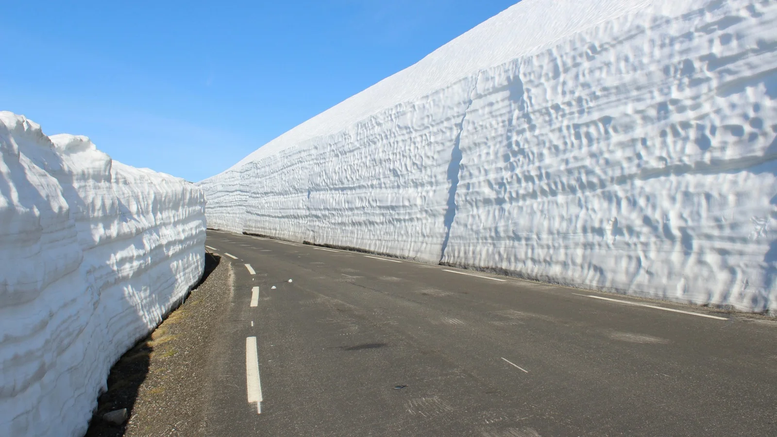
Spring is the narrow window when the Snow Corridor opens, snowmelt charges every waterfall, and the highlands just start greening at the edges.
Day 1
Cable cars, a museum about medieval hell paintings, and a marshland where the trees give up and the wind takes over.
Tateyama Station
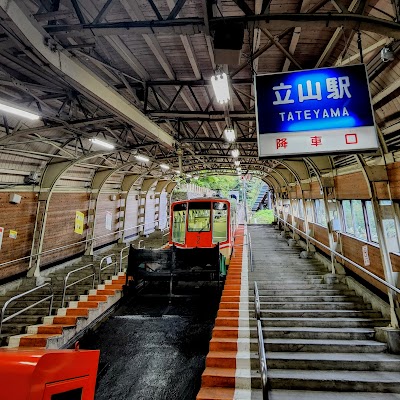
Tateyama Station is where the crossing begins: the last place with cell signal and hot coffee before the mountain. People have been climbing this route for a thousand years, believing the mountain was a gateway to both paradise and hell.
Grab the through-ticket here and forward your luggage at the counter first, because that deadline is firm and easy to miss. The cable car climb through cedar forest is a quietly beautiful transition most riders are too busy fumbling with tickets to notice.
Tip: Arrive early to purchase Alpine Route passes and forward luggage at the counter before boarding the cable car ascent through the forested lower slopes.
Mandala Yuen (Tateyama Museum of Toyama)
Five minutes from the station, a small museum almost nobody visits, and it changes how you see the entire route. Inside, mandalas show pilgrims being led through rivers of fire, basically medieval tourism brochures for the afterlife.
Tateyama was one of Japan's three sacred mountains, and believers donated to its temples like spiritual insurance for a better afterlife. Walk through before the cable car because it makes the volcanic vents higher up feel intentional instead of random.
Tip: Walk through exhibits on Tateyama mountain worship traditions and centuries-old mandalas; check opening hours as the museum closes earlier than the station.
Midagahara
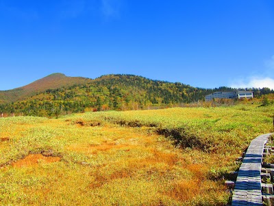
Midagahara is where the landscape stops being a forest and becomes open, wind-scoured alpine plateau at nearly 2,000 meters. Boardwalk trails cross a wetland with the Tateyama range rising behind it, the first real visual payoff of the altitude.
Most people stay on the bus through here, which means if you get off, the boardwalk is almost yours alone. Whatever temperature you think it is, subtract more. The wind at this altitude does not care what the valley felt like.
Tip: Stroll the elevated boardwalk across the marshland with views of the Tateyama Mountain Range. Wear warm layers as alpine winds pick up even in spring.
Day 2
Today is the reason you came. The highest point on the route, volcanic vents hissing sulfur, and a crater pond that reflects mountains.
Murodo Terminal Rooftop Viewing Platform
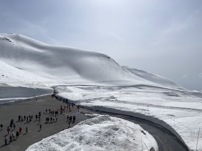
At 2,450 meters, Murodo is the highest point on the Alpine Route and the hub for everything famous about it. The rooftop platform gives a full-circle mountain panorama, and on a clear morning it justifies every transfer that got you here.
Get up here first thing because clouds build through the day and you cannot predict when they will take the view. In spring the whole area is still a snow island. Buildings connect via carved pathways through drifts, and sunlight bouncing off white is so bright that squinting is mandatory.
Tip: Step onto the rooftop viewing platform for 360-degree mountain panoramas and direct Snow Corridor access; reserve morning time when clouds are less likely to obscure peaks.
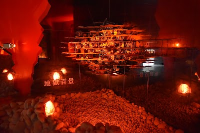
Noboribetsu Jigokudani Valley
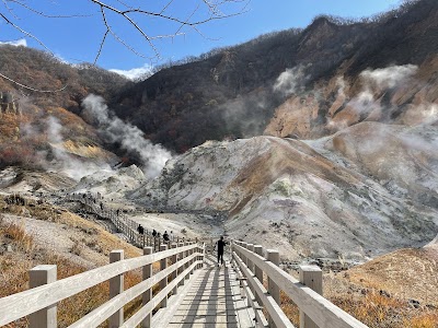
Ten minutes from the terminal, the ground opens up and starts venting steam and sulfur. The mountain's hell, still earning the name. Pristine snow on one side, yellow-stained hissing rock on the other, and sulfur hitting you before you even see the source.
The mandalas at the museum showed demons in these exact valleys. Standing here with steam on your face, the paintings feel less metaphorical. Stay on the marked path because the ground near the vents is genuinely hot and unstable. Those fences are not decorative.
Tip: Follow the short walking trail past steaming volcanic vents and bubbling pools; stay on marked paths as the ground near fumaroles can be dangerously hot.
Mikuriga-ike Pond
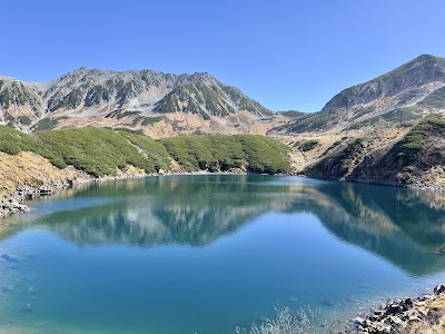
A short walk from Murodo, a volcanic crater lake reflects the surrounding peaks like a mirror on calm days. It is the most photographed spot on the route. The mountain gives you a window and closes it: still air means a perfect reflection, and once the breeze picks up, it is just ripples.
Walk the full loop instead of clustering at the photo spot because the far side is quieter with completely different peak angles. In spring the pond can still be half frozen, half open water. Two completely different moods in one short walk around a crater.
Tip: Walk the easy loop around the crater pond reflecting the Tateyama peaks; arrive before afternoon clouds roll in for the clearest mirror-shot reflections.
Day 3
The descent: a gorge crossing by ropeway, Japan's tallest dam, and an onsen at the end that ties the whole thing together.
Daikanbo
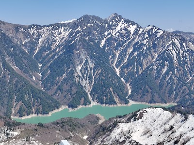
Daikanbo is where the route pivots from the high plateau and begins descending into the Kurobe gorge below. You are in a glass box over a gorge so deep the river looks like a thread. The ropeway ride is half the experience.
Spring streaks the gorge walls with snowmelt waterfalls that will be gone by summer, a detail that only exists for a few weeks. Face the gorge on the platform because the view is the whole point, and the window for clear air is shorter than you would expect.
Tip: Transfer via the Tateyama Ropeway to this scenic overlook with 360-degree gorge and peak views; board early to avoid midday crowds competing for the viewing platform.
Kurobe Dam
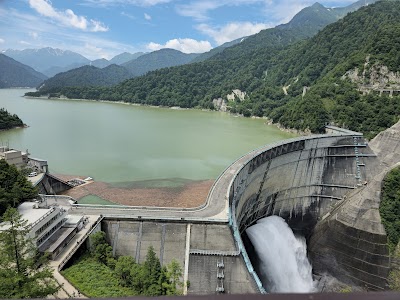
Japan's tallest dam at 186 meters, a curved wall holding back an entire alpine lake, and the engineering payoff of the whole route. It took decades and was considered nearly impossible. The terrain was so remote that all materials had to be lowered in from above.
Walking the crest you feel the rumble of water releasing from the base and cold spray on your face. Awe and unease mixed together. Walk the full width because the perspective shifts as you cross, and the far side gives the best view back toward the wall.
Tip: Walk across the 186 m dam crest for spray-level views of the reservoir and surrounding peaks; spring snowmelt fills the basin dramatically at this time of year.
Kurobe Kanko Hotel
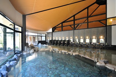
After three days of altitude, wind, and sulfur, you get to sit in hot mineral water and let the mountain go. The water comes from the same volcanic system you just walked across. You are soaking in the mountain's exhaust, and after three days of cold, it feels like an apology.
If you have never used a Japanese onsen, read the basics first: rinse before entering, no swimsuits, tie your hair up. Book ahead during spring weekends because Alpine Route traffic fills these places, and the best ending is not negotiating day-use availability at the front desk.
Tip: Soak in natural hot springs after the full alpine crossing; book an onsen bath in advance during peak spring season weekends when the route is busiest.
What to book ahead
- Purchase Alpine Route open ticket (2-4 weeks before) - Single pass covers all six transport modes; buy online for a small discount
- Forward luggage Tateyama → Ogizawa (Morning of Day 1) - Coin-operated luggage forwarding available at Tateyama Station; no large bags on cable cars
- Reserve onsen hotel near Ogizawa (1-2 months before spring season) - Kurobe Kanko Hotel and nearby inns fill quickly during peak Snow Corridor weeks
- Check route opening dates (Before booking flights) - Full route opens mid-April; Snow Corridor walls are tallest in April–May
What to pack
Essentials
- Warm layered clothing - Temperatures at 2,450 m can drop below freezing even in late spring
- Sturdy walking shoes - Boardwalk trails at Midagahara and paths around Murodo are uneven
- Sunscreen and sunglasses - High-altitude UV and snow glare are intense on the Snow Corridor
- Daypack - Luggage forwarding is recommended; carry only essentials on the route
Nice to have
- Trekking poles - Helpful for stability on snowy or muddy sections near Murodo
- Thermos flask - Hot drinks are scarce on the high plateau; fill at your hotel
- Camera with wide-angle lens - Snow walls and gorge panoramas demand a wide field of view
Final take
Three days of volcanoes, snow walls, cable cars, and one very large dam. The kind of crossing that changes what you think a mountain trip can be.
Plan this trip
Turn this guide into an editable trip plan
Open the route in Instaboard, adjust the stops, and share the itinerary with your travel group.